
Investigating Neighborhoods: What Hidden Histories Can Neighborhoods Reveal?
We often cease to notice the particulars of places that we see or visit daily. Art is a tool that can help us to perceive or observe our environments differently. By being careful observers of their surroundings, artists sometimes notice things that we might overlook, helping us to see spaces, environments, and neighborhoods with new eyes.
With Day’s End, Hammons broadens our perceptions of our environment. The artist calls attention to a space that no longer exists by subtly referencing Pier 52 and, in turn, Gordon Matta-Clark’s artwork. The work’s transparency also enables us to see other things currently happening in the delineated space. Because of the installation’s design and materials, its appearance varies in the changing light.
Meatpacking District
The Meatpacking District gets its name from the meatpackers who used to occupy the neighborhood. There are only a few remaining meatpacking companies here today. The irregular streets of Greenwich Village and the grid from the 1811 Commissioners plan created large intersections like Gansevoort Plaza as well as unusually shaped blocks and buildings. Most of the buildings in the Meatpacking District were one to six story buildings with brick façades, constructed from the 1840s to the 1940s. The corrugated iron awnings, distinctive to this area, were installed to shield produce and meat from the sun. The building which stands across from the Whitney was a refrigerator warehouse.
From about 1851, Belgian sett—granite blocks—paved the streets. They were used as ballast, which is heavy material placed in ships to stabilize them as they traveled across the Atlantic Ocean from Europe to New York City. The blocks were tossed ashore for the return journey because the ships were filled with cargo. Now they’ve been replaced with fresh granite stones.
Fort Gansevoort was a former United States Army fort, built in 1812. It was located between Gansevoort Street and West 12th Street. It was positioned there in order to defend the Hudson River. In 1854, the Hudson River Railroad freight depot was built at Gansevoort and Washington Streets at the site of the Whitney. The railroad was owned by William Henry Vanderbilt, the grandfather of the Museum’s founder, Gertrude Vanderbilt Whitney. The section at 10th Avenue and Little West 12th Street was known as the “Avenue of Death” because steam engines, which ran on the street plowed through, unaware of pedestrians and cars. Because of numerous accidents, men on horseback known as “Death Avenue Cowboys” or “West Side Cowboys” rode in front of the trains, carrying red flags during the daytime and lanterns at night. Between 1856 and 1908, 436 people had been killed on the line.
By 1934 the railroads along 10th Avenue were replaced by the High Line, an elevated freight route that extended from West 34th Street to Spring Street and passed through thirty warehouses along the way. The High Line was used by trains until 1980. In 2009, Friends of the High Line selected landscape architecture firm Diller, Scofidio + Renfro, and Piet Oudolf, planting designer, to transform the remaining sections of the elevated train line into a park which is enjoyed by millions of people today.
The Gansevoort Market Meat Center shares the block with the Whitney between Washington and West Streets. In the 1860s, farmers from New Jersey and Long Island began selling fruits and vegetables at this site, and the city opened the Gansevoort Farmer’s Street Market in 1884. It was replaced by the Gansevoort Market Meat Center in 1949–50. Slaughtered meats were transported to the market to be butchered and dressed. The Meat Center went into decline in the 1970s and 1980s because of advances in refrigeration, aging buildings that were not up to code, and the newer meat market locations at Hunts Point in the Bronx.
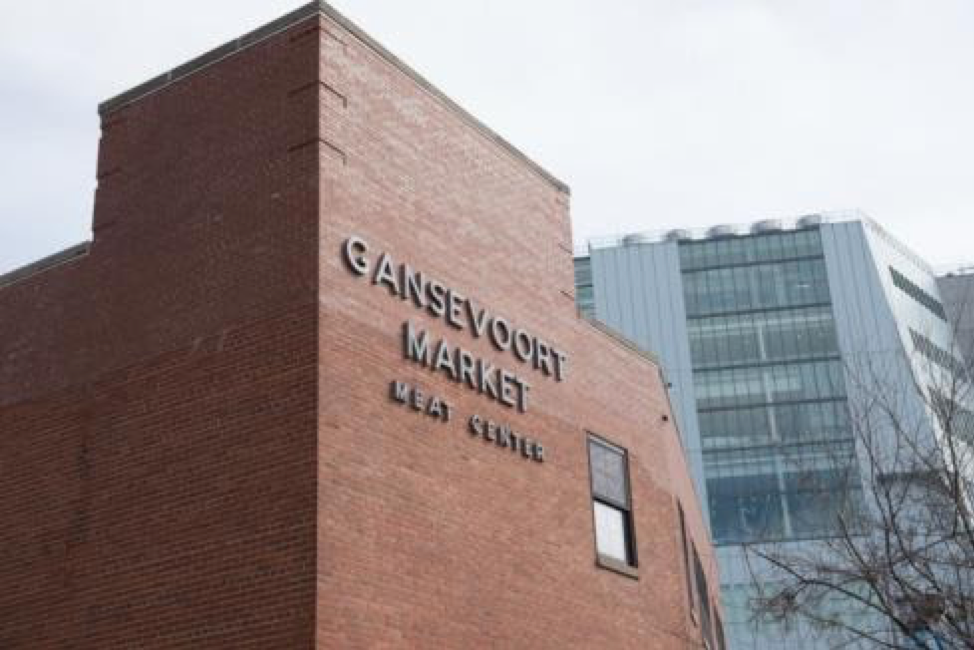
Gansevoort Market Meat Center, north of the Whitney, 2015. Photograph by Timothy Schenck
Activities
Elementary School
Explore What Makes a Neighborhood
Ask students to think about and discuss what makes up a neighborhood. What are some characteristics of that neighborhood? What is special about it? Ask them to write a description that creatively shares these attributes.
Draw Attention to an Overlooked Place
Encourage your students to think of a place in their room, home, or neighborhood that they want to bring attention to and that might be overlooked because it is changing. Ask them to choose the materials or ways they could encourage others to notice it. As one option, they could create a map of the highlights of their room, home, or neighborhood.
Create a Personal Map
Invite students to create a map of their neighborhood that focuses on the places that are most special to them. Ask students to think of their favorite buildings, parks, businesses, or other special places in their neighborhoods. Why did students choose those places: What do they do there? Who do they interact with? On their map, how might they show that those places are important to them? They might consider using colors, symbols, and scale, or size, to help communicate the importance of those places.
Take a Neighborhood Walk
Invite students to take a walk around their neighborhood, either as a class or with their families, and pay attention to details that they think other people might not notice. This could include architectural details on buildings, empty spaces between or around objects, shadows and lines, or anything they think others might not pay attention to. Ask students to document and share those details through photographs, sketches, and/or written notes. Encourage students to take the same walk again later in the year to see how those details have or haven’t changed, and document new details that they notice.
Middle and High School
Imagine a Future Neighborhood
Ask your students to imagine what their neighborhood might look like in 2050 or 2100. Have them propose ways for communicating how they envision street grids, buildings, traffic, and flight patterns might look like.
Make History Visible
Ask students to research the physical features, parameters, streets, maps, and architecture of the historic Black (“half freed” slaves) or Lenape settlements in lower Manhattan. Invite them to devise a creative means to celebrate and make others aware of these geographic histories today.
Explore Gentrification in the Neighborhood
Gentrification and its ramifications can occur in very subtle ways. Discuss with students what changes they have noticed in their neighborhoods during their lifetimes. Have them debate about what changes they think are positive and should be adopted and which ones they think are harmful in their neighborhoods, such as the loss of small businesses, the building of new housing that might not be affordable for current residents, for example. Invite them to make artworks or a call to action to make others aware of their opinions and findings.
Additional Resources
Urban Archive: Interactive map of New York City and related historical images.
Greenwich Village Society for Historic Preservation: Greenwich Village history.
Greenwich Village Society for Historic Preservation: Gansevoort Market Walking Tour.