
Examining the Hudson River and Evolving Coastline: How Can We Address Changes to Our Environment?
Art invites us to change the ways that we see and think. This installation, which is situated both in the river and on the Pier, invites us to reflect upon our environment. The work’s transparency also allows us to pay attention to the easily overlooked details of the Hudson River coastline, the daily ebb and flow of river traffic, seasonal shifts, ecological diversity and loss. With this public art project, Hammons also opens up broader reflections on environmental changes that have occurred over time, and are not overtly visible, such as urban and maritime development, economic and climate change, and issues of sustainability.
Piers 52, 54, and 55
Pier 52 was first created in the 1840s as a place for people to dump trash. At the end of Gansevoort Street, the pier probably functioned as a “dumping board” where garbage was collected and pushed overboard into boats, or directly dumped into the Hudson River. Gansevoort Peninsula and Pier 53 were constructed from more landfill in 1851. The city built the West Washington Market on the Gansevoort Peninsula in 1889. The market provided wholesale facilities for meat, poultry, eggs, and dairy products. It became even more popular the following year when brine-cooled water began to be pumped under West Street from the Manhattan Refrigeration Supply Company. From 1894−1910, the landfill was dredged to construct long piers that accommodated transatlantic steamships. This area became the busiest section of the Port of New York.
In 1950, the Department of Sanitation took over the Gansevoort Peninsula. They built what was locally known as “The Gansevoort Destructor” where trash was incinerated. At that time, the piers off the Peninsula abutting Pier 52 were used to transfer garbage from trucks into barges to be shipped to Staten Island or New Jersey. From the 1950s, Pier 52 also served as a recreation spot. A New York Times headline from June 1959 reads “The River’s Dirty, But the Sun’s Fine” in an article which describes people sunning, fishing, and swimming at Pier 52. On this particular day in June “many eels were being landed, and eels put up an impressive fight.” Despite the fact that this was “just downstream from the garbage scow loading point” at the Department of Sanitation on the Peninsula, “small and medium-sized boys” were swimming in the “green opaque water.” Before it was torn down around 1979, the shed was used as a warehouse by the Baltimore and Ohio Railroad Company.
Piers 54 and 55 also have amazing histories. Pier 54 was the docking station for the Cunard Company, a big boating company. The survivors of the Titanic were also brought to Pier 54 by boat in 1912. The Lusitania was a British ocean liner, which sailed from Pier 54 in 1915 and was later sunk off the coast of Ireland by German U-boats during World War 1. This proved to be instrumental in the United States’s entry into the war. The survivors of the Titanic were also brought to Pier 54 by boat in 1912. Later in history, in 2013, Piers 54 and 55 had fallen into disrepair and were further damaged by Superstorm Sandy. Barry Diller and the Hudson River Park Trust worked together to create a plan to renovate this site, building a public structure called “Little Island.” Little Island will open to the public in 2021 and will feature landscaping, recreation, and performance spaces.
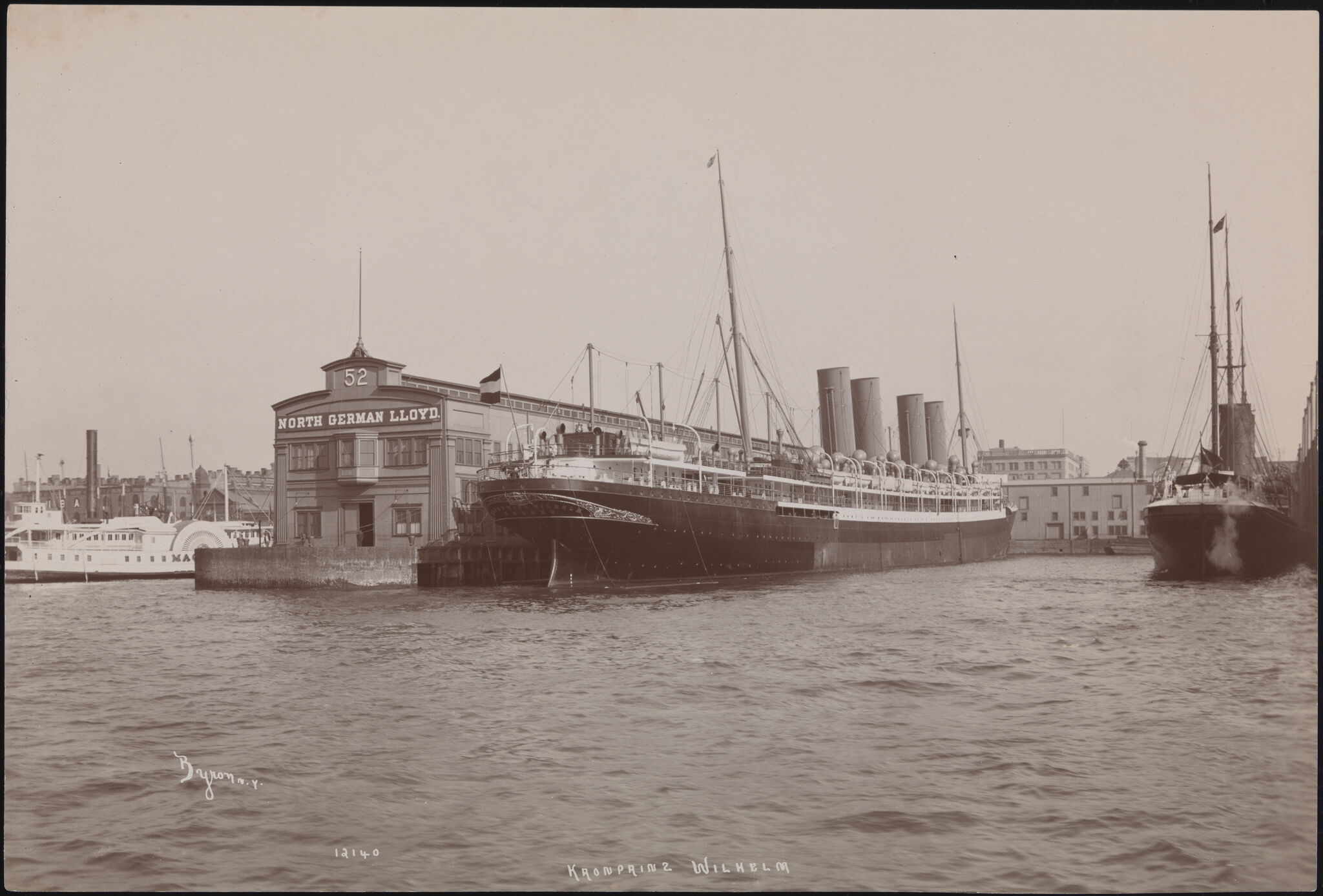
SS Kronprinz Wilhelm at Pier 52 (detail), c. 1901. Museum of the City of New York, 93.1.1.13637
River Traffic
Hammons’s Day’s End shares the Gansevoort Peninsula with the New York City Fire Department's Marine Company One, a fire station and dock on Pier 53. It is one of only three New York City fire stations on the water and it is also a Homeland Security facility. The zinc-clad, angular building opened in 2011. It has sleeping quarters, a kitchen, a workout room, storage space, and anchorage for several fireboats. The “343” is Marine One’s 140-foot fireboat. This boat was put into service on September 11, 2010, and is named after the number of firefighters killed in the line of duty on 9/11. To put out fires, gallons of river water is sprayed through water-firing nozzles on the boat, which can pump 50,000 gallons of water per minute.
The Hudson River is an important transportation route, known as US Marine (or Blue) Highway M-87. Marine highways are extensions of the surface road system, and also under control of the federal Department of Transportation. This highway is travelled by ferries, barges, tugs, and the occasional tanker or cargo ship going back and forth to the Port of Albany, 150 miles upriver from the Whitney. The barges and tankers carry products such as oil, gasoline, machinery, and sewage sludge.
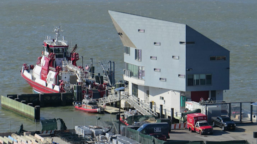
Marine Company One on Pier 53, 2020. Photograph by Laura Protzel
River Wildlife
The Hudson River flows 315 miles in both directions from an Adirondack mountain lake in upstate New York called Tear of Clouds to the Atlantic Ocean. The Hudson is called an estuary because it is a mixture of both salt and fresh water where the river meets the sea. A viewshed is an area that encompasses the lines of sight (or view) from a fixed location. The western facade of the Whitney Museum looks across West Street to the Hudson River, which for about 300 years was a vital conduit for development, commerce, and transportation for New York City and the region.
Within the Whitney’s viewshed, strong tidal currents traverse the river which is almost a mile across to New Jersey. The City of Hoboken is directly across from the Whitney Museum. Across the river on the New Jersey side, a buoy monitoring station that’s part of the Hudson River Environmental Conditions Observing System (HRECOS) collects water quality data every fifteen minutes. Wildlife is teeming below the river’s surface, including fish, eels, mollusks, shrimp, crabs, worms, oysters, seahorses, and plants. Over seventy types of fish live in this part of the river and more than 100 species of birds live close by.
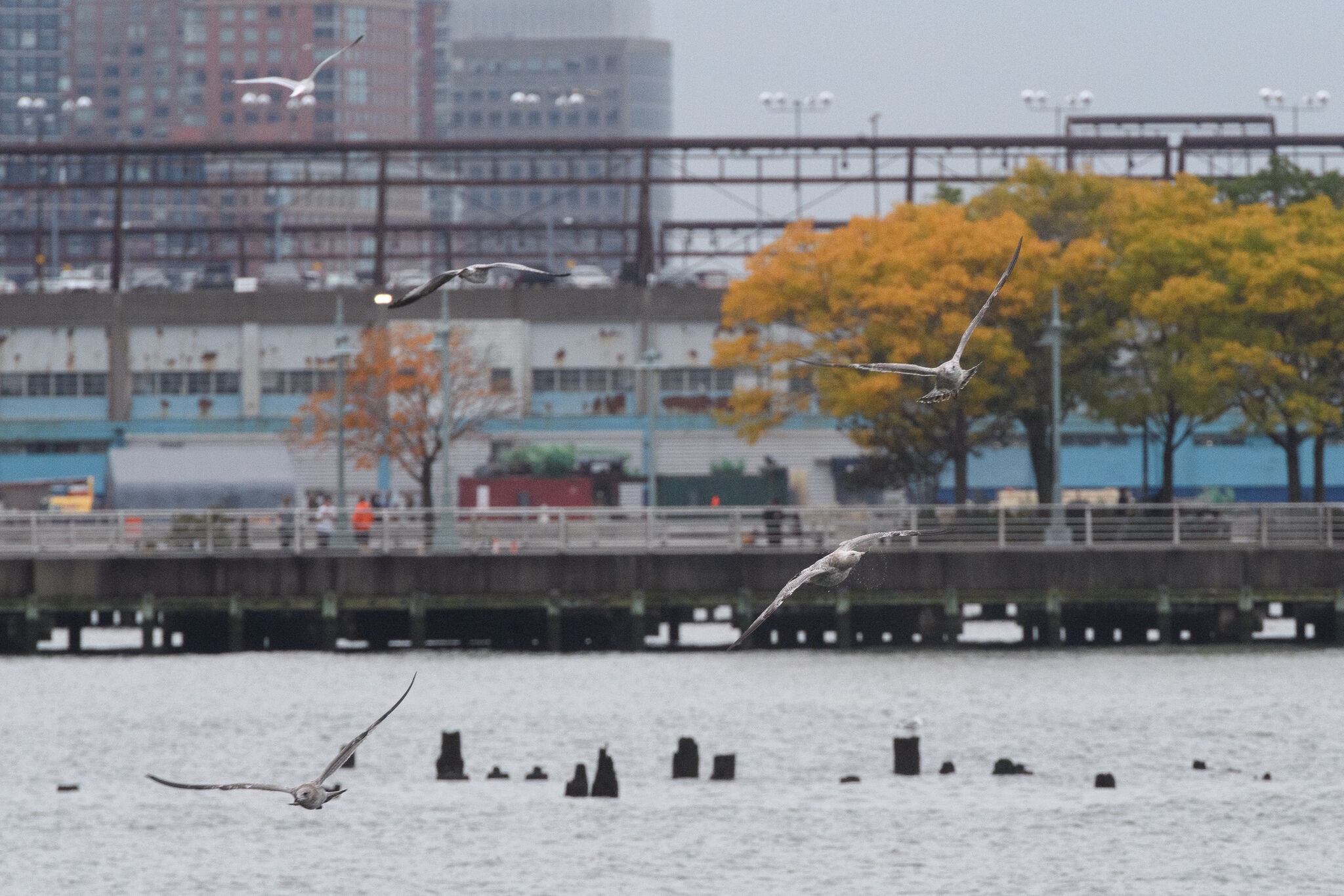
Hudson River, 2020. Photograph by Filip Wolak
Activities
Elementary School
Communicate Changes in the Natural Environment
Encourage your students to pay attention to the nature around them. For example, plants, animals, and weather. Ask them how they could creatively communicate the changes they see daily, weekly, or monthly.
Provide time for students to regularly record environmental observations in a nature journal. They might make detailed sketches and notes about trees, plants, and animals, create rubbings of different natural textures they encounter, and tape or glue in samples of soil, pollen, or fallen petals. Students could also explore color mixing with pencils, crayons, or paint, by trying to accurately document the colors of sky, clouds, or water on different days.
Create a Publicity Campaign about Climate Change
Have your students research maritime plants and species that currently populate the Hudson River or other source of water they are familiar with. Encourage them to research how climate change is affecting this environment. Ask them to create a publicity campaign to protect these plants and species.
Enact Preservation
Introduce students to the concept of preservation, which means protecting and maintaining something so that it continues to exist. Invite your class to create a list of things and places they think are important to preserve. Choose one or two subjects from the list, which your class believes they can actively help preserve, and invite them to come up with a plan for how they will do this. For example, if they want to preserve a river, maybe they can help fundraise for an organization that cleans or protects the river. If they want to preserve a local business, maybe they could write letters to a local newspaper about how much the business means to them, or create signs advertising the business around the school. Encourage students to continue working on their preservation project over the course of the year.
Middle and High School
Record the Passage of Time in a Particular Place
Ask students to devise an obvious means of showing the passage of time in a space or place that is not immediately visible. For example, frame an area of the ground with tape or string and see what changes occur through the effects of nature over time. Invite students to create an object that communicates their work.
Create an Artwork that Shows the Impact of Changing Ecology
Have students listen to and discuss the Whitney’s podcast, Artists Among Us (Episode 4 - “Coastline Cultures: The Evolution of Manhattan’s Waterfront”: coming June 4, 2021). Challenge students to create an artwork or action that vanishes or is destroyed by the deteriorating ecology of the Hudson River or other water source they know. For example, they could bring attention to the effects of climate changes on the Hudson River ecology by creating a work on the river’s edge or the pylons that disappear if the water rises. How could their work bring attention to the loss of some species, flora, or fauna in its actual construction?
Design a System for Improving Ecological Conditions
Ask students to research the historic and current West Village and Meatpacking District ecologies of recycling, waste management, and/or urban sustainability. Motivate them to design new creative systems to improve conditions today and devise publicity to promote them for these or their own neighborhoods.
Invent a Creative Solution for Extreme Weather Changes
The effects of climate change have made many populated areas vulnerable to destruction. The location of the Whitney Museum, adjacent to the Hudson River, makes the building sensitive to water level rise and storm surges. Have students research the Whitney Museum building’s architectural design and flood mitigation strategies including: the FEMA recommended 13.5-foot elevation for construction, temporary wall systems, 10-inch-thick aluminum and steel floodgates, prioritizing exhibition galleries on the upper floors, etc. Encourage students to research and choose a site made vulnerable because of climate change. Invite them to think critically and design their own creative solutions for flood mitigation, storm surges, and extreme weather changes and present them to the class.
Propose a Recreational Space for an Under-used Location
The High Line re-envisioned old railroad tracks in Manhattan and the designer Thomas Heatherwick’s Pier 55 creates a new gathering space along the Hudson River. Students could divide into small groups for this activity. Ask students to think about their own neighborhoods and areas that might currently be abandoned or perhaps under-used. Have them make real or imagined proposals for a park or recreational space to local government representatives, including rationale and blueprints. Have them present their proposals to the class.
Additional Resources
Hudson River Park: Resources and projects for school students and teachers.
Department of Environmental Conservation: Hudson River Estuary Program lesson plans, grades K–7.
The Cary Institute of Ecosystem Studies: The Changing Hudson Project features web-based curriculum designed by teachers and scientists to engage high school students in exciting, innovative science connecting them with current research about the river.
United States Geological Survey: Extensive information about U.S. rivers and real-time data. Includes teacher resources for water science.
Hudson River Environmental Conditions Observing System (HRECOS): Includes lesson plans, PowerPoints for download, a live webcam on the river at Marist College, and other tools to measure and interpret river data.
Riverkeeper: Riverkeeper's mission is to protect the environmental, recreational and commercial integrity of the Hudson River and its tributaries, and to safeguard the drinking water of New York City and Hudson Valley residents.
The Cary Institute of Ecosystem Studies: Information about the Hudson River.
Hudson River Sloop Clearwater: Information about their sailing classroom and curriculum.
NY Sea Grant: Developed by NY Sea Grant and the Estuary Program, these nine lessons help middle school students understand climate and weather basics and explore climate-related issues close to home in the Hudson River Valley.
National Geographic: Extensive information about rivers in general, and teacher resources, including lesson plans, maps, and references. Also features interactive mapping tools and other online features.
Billion Oyster Project: A project to restore oyster reefs to New York Harbor through public education. Includes information and curriculum.